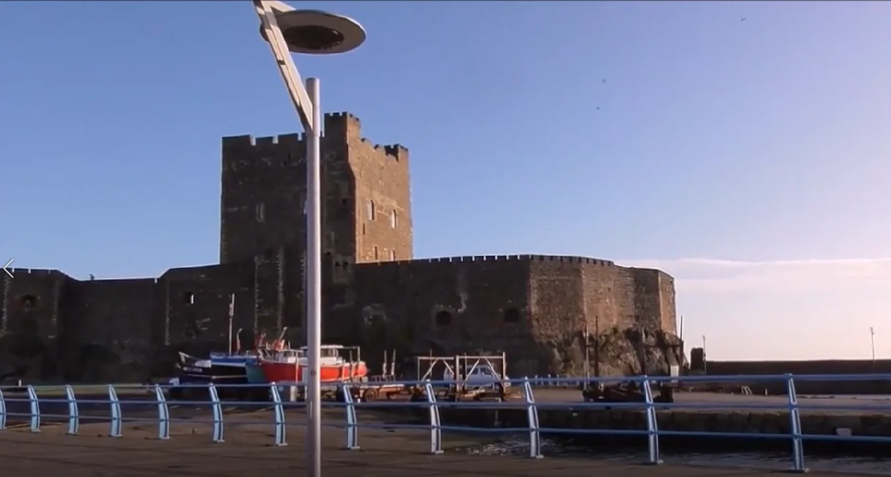
Carrickfergus Castle has to be the best preserved Norman castle in the whole of Ireland. It represents authentic living history. It is disappointing that Carrickfergus Castle is not promoted by tourist chiefs the way it deserves. This is my wee video walkround.
Carrickfergus Castle (from the Irish Carraig Ḟergus or "cairn of Fergus", the name "Fergus" meaning "strong man") isthe top Norman castle in Northern Ireland. It is situated in the town of Carrickfergus in County Antrim, on the northern shore of Belfast Lough. Over the years it has been besieged in turn by the Scottish, native Irish, English and French! It remains one of the best preserved medieval structures in both Northern Ireland and the island of Ireland. It was strategically useful, with 3/4 of the castle perimeter surrounded by water (although in modern times only 1/3 is surrounded by water due to land reclamation). Today it is maintained by the Northern Ireland Environment Agency as a state care historic monument. Carrickfergus was built by John de Courcy in 1177 as his headquarters. After he conquered eastern Ulster he ruled as a petty king. He was ousted in 1204, by another Norman adventurer, Hugh de Lacy. Initially de Courcy built the inner ward, a small bailey at the end of the promontory with a high polygonal curtain wall and east gate. It had several buildings, including the great hall. From its strategic position on a rocky promontory, originally almost surrounded by sea, the castle commanded Carrickfergus Bay/ Belfast Lough, and the land approaches into the walled town that developed beneath its shadow. After the collapse of the Earldom of Ulster in 1333, the castle remained the Crown's principal residential and administrative centre in the north of Ireland. During the sixteenth and seventeenth centuries improvements were made to accommodate artillery, including externally splayed gunports and embrasures for cannon, though these improvements did not prevent the castle from being attacked and captured on many occasions during this time. Marshal Schomberg besieged and took the castle in the week-long Siege of Carrickfergus in 1689. This is also the place where Schomberg's leader, King William III first set foot in Ireland on 14 June 1690. In 1760, after fierce fighting in the town, it was surrendered to French invaders under the command of Francois Thurot. They looted the castle and town and then left, only to be caught by the Royal Navy. American War of Independence In 1778, a small but significant event in the American War of Independence began at Carrickfergus, when John Paul Jones, in the face of reluctance by his crew to approach too close to the Castle, lured a Royal Navy vessel from its moorings into the North Channel, and won an hour-long battle. In 1797 the Castle, which had on various occasions been used to house prisoners of war, became a prison and it was heavily defended during the Napoleonic Wars; six guns on the east battery remain of the twenty-two that were used in 1811. For a century it remained a magazine and armoury. During the First World War it was used as a garrison and ordnance store and during the Second World War as an air raid shelter. It was garrisoned continuously for about 750 years until 1928, when its ownership was transferred from the British Army to the new Government of Northern Ireland for preservation as an ancient
I reckon I just got a good deal from Homebase today.
A Qualcast 1500W Rotary mower for £55 with a Qualcast 350W Strimmer thrown in. Check it out for yourself.
I thought I would treat myself to a new Video camera in the January sales. This is my new Camcorder bought on line from Jesspos for £238. It's a Twin camera Panasonic HC-W580. I bought it mostly because it offers good stabilization and high quality long range zoom options. The zoom is amazing.
I previously forgot to mention the special option where you can use the reverse camera located on the side of the LCD monitor. This means you can film something while simultaneously capturing either the videographer’s reaction or another angle of the event. This footage appears in a small box in the left bottom side of the main screen.
Binder's Cove Souterrain Finnis Dromara. ( Bring a strong flashlight and wear strong hats or better still cycling helmets and good gloves and old jeans)
The name comes from the French. 'Sous' meaning under and 'terrain' meaning earth.
This has to be a very strong contender for best preserved in Ireland and longest souterrains in Ulster! This Binder Cove souterrain dates from early Christian times around the 9th century. It is well under an hour's journey out of Belfast. It is close to Dromara and closer still to the small village of Finnis in the shadow of Slieve Croob. It is easily found because of road signage and a well defined pathway leading right up to the entrance. Once inside switch on the solar powered lighting. This is s very well preserved souterrain. It should be completely dry, no muddy floor.
The floor has a loose gravel covering. During the winter months the tunnels may be flooded so the gate is locked.The key may be obtained from O'Hare's garage on the B7 Rathfriland Road, near Finnis/Massford.
This souterrain, near the settlement of Finnis, and just down the road from the impressive Legananny portal tomb, was rediscovered in the early eighteenth century. It was originally referred to simply as the “Finnis Cave,” but was also known by the name of the nearby peak, Slieve-na-Boley. The site took its modern name from a previous owner of the field (“Binder”) and a corruption of the English and Irish words for “cave.”
Binder’s Cove has a short entrance passage, 2 m (6.5 ft) long, with only a meter (3.3 ft) of height, with a low lintel stone at the end that might break the head of an intruder rushing into the dark tunnel. After that constriction, the main passage at Binder’s Cove is about 30 m (98.5 ft) in length, with two side passages that are each about 6 m (20 ft) long. The main passages have about 1.5 m (5 ft) of headroom, and are about 1 m (3.3 ft) wide.
Further
Finnis Souterrain, is a securely built underground structure made up of three passages. The main passage runs from east to west for approximately 29m.
It is made of granite, with large stones near the base giving way to smaller stones, creating an inward batter or curve. The main passage sidewalls are characterised by an outward stepping of the top most wall course, which provides a platform or ledge onto which the massive roof lintel stones were set. Two side passages extend from the central passageway in a north easterly direction, and there are low lintels at the entrance of each of these chambers. The chambers are both around 6m in length.
In the first side passage, the constricted entrance is formed by large lintels. A roof aperture above these lintels possibly provided a vantage place for someone to hide and surprise an unwelcome intruder. Finnis Souterrain is known locally as ‘Binder’s Cove’. According to Mark Clinton, souterrains were commonly referred to as ‘an uamh’ or cave. He also states that the given price for building a souterrain was two cows. ‘Binder’ was the nickname given to a previous occupier of the souterrain field.
Souterrains date from the early Christian period, between the sixth and tenth centuries AD. This was a period of civil unrest, with the constant threat of Viking raids, intertribal cattle raids, and regular theft of slaves. Although there is some debate about the purpose of souterrains, it is thought that they were built mainly as places of refuge, but were used for storage on a day to day basis. Finnis Souterrain would have made a useful cool store in the summer.
The present entrance to the souterrain is not the original access point, the location of which is not known. Archaeologists think that the main passage continued beyond the present entrance. A report in the Northern Whig in 1836 refers to stone steps leading down to the souterrain, but these have never been found. It is not known when the present entrance to the site was made. Finnis Souterrain has been known for at least 200 years, but has been ‘rediscovered’ many times.
I've come up this morning to the windswept Boghill road just a few miles from the Sandyknowes roundabout at Mallusk, to pay homage to a young Polish WW2 airman.
Somewhere nearby Flight Sergeant Wladyslaw Kolek of No. 315 Polish Squadron met his death during a training sortie on September 11, 1943. Last year a memorial was finally erected in Co Antrim.
The 26-year-old crashed into a farm house near RAF Nutts Corner after he got lost in bad weather conditions.
The memorial to the pilot was unveiled last year at Boghill Road, Mallusk, and is part of a Polish Wings Heritage Trail created by Antrim and Newtownabbey Borough Council and their partners Your Freedom and Ours.
Poland's Consul General Pawel Majewski was in attendance and said: "It is my hope that this memorial will show every person the famous gallantry of Polish airmen during World War Two. Those Airmen who bravely defended the shores of Northern Ireland and the United Kingdom and paid the highest price for our freedom.
Polish Flight Sergeant Wladyslaw Kolek is gone but not forgotten.
Belfast Live News Article
https://www.belfastlive.co.uk/news/belfast-news/co-antrim-memorial-polish-world-21193859
This is the Murland Family Mausoleum sittind at the back of Clough Non-Subscribing Presbyterian Church, Castlewellan Road, Clough, County Down just aross the road from Frenchies Restaurant.
Here we have a finely carved crypt built in the neoclassical/baroque style with pedimented gable end topped by urns. It has a stone pitched roof with steps leading down below ground to a metal door. Above a rounded recessed opening with metal grill with an archway is decorated in rusticated style. The gable walls support a low pediment adorned with acanthus
( flower ) and scrollwork detail. Giant order of consoles flanked by flambeau ( torches ) support a cornice. The roofline boasts acroteria, ( -An acroterion or acroterium or akroteria is an architectural ornament placed on a flat pedestal called the acroter or plinth, and mounted at the apex or corner of the pediment of a building in the classical style ), antefixae (-An antefix, from Latin antefigere, to fasten before, is a vertical block which terminates the covering tiles of a tiled roof ) and draped urn finials.There are marble plaques inserted along the tomb sides and a granite plinth.
The stone is buff-pink sandstone with the primary stone being Giffnock sandstone imported from Glasgow.The secondary stone type is Newry granodiorite. The inserts are marble.
The draped urns on the roof of the building were -common in Victorian cemeteries. They symbolise a separation between the living and the dead and a protective shroud for the soul. They are a classically inspired symbol of death.
This then is no ordinary tomb. The Murlands were at pains to emphasis that they were no ordinary family. Their mausoleum dominates the graveyard and is very out of keeping with the more humble graveheadstones from the period. No expense has been spared here and no detail neglected in the construction. The Murland family were the linen industry in this South Down region and that this mausoleum was built in 1860.
A lot of the very interesting Murland family story can be found detailed in the 2008 book titled 'Departed Warriors -the Story of a Family in War' by Jerry Murland.
'Departed Warrirs Takes the reader from the shores of Britain with the first volunteer army to leave for South Africa to fight in the Second Boer War, and to the battlefronts of the Great War of 1914-18. This work offers an account of two generations of a family who fought for their country and the impact it had upon their lives.'
Jerry Murland served in the Parachute Regiment. He is the author of Departed Warriors and Aristocrats Go To War (Pen and Sword Military). He is a prolific writer of military books dealing with WW1 and WW2. He lives near Coventry.
This spectacular 19 year old European Eagle owl was hand reared by Don the Owl man from Newtownards Co Down. It is the largest of the world's owls. We saw it at Castle Espie Comber.
How to clean flagstone paths easily quickly and cheaply.
Garden concrete paths and flagstone paving will soon go green with algae or dirty up with mud. Here's how to reinstate them to the clean white that they should be.
N B 1
This is only a suggestion. It is only what I do to bring up the concrete whiteness.
N B 2
Be very careul this Sodium Hypochlorite, even though you have diluted it. Wear glasses, gloves old clothes and wellies and do not inhale as you pour liquid. Watch out not to splash yourself. Do not use when children or pets will be near. It is a nasty corrosive.
Once or twice a year cleaning should be sufficient.
This is Spanish Frigate the Almirante Juan de Borbon (F102) in Pollock Dock Belfast. This ship was part of a task force of 5 Nato vessels that dropped into Belfast over this weekend for some R n R.
Almirante Juan de Borbon F102 is an all-modern Spanish Navy air-defense frigate outfitted with a bevy of weaponry types for the role. Almirante Juan de Borbón (F-102) is the second ship of the new F-100 class of air defence frigates entering service with the Spanish Navy in 2003. It is named after Infante Juan de Borbón, Count of Barcelona, father of the former King of Spain, Juan Carlos I.
Name: Almirante Juan de Borbón
Namesake: Infante Juan de Borbón, Count of Barcelona
Builder: Izar
Class and type: Álvaro de Bazán-class frigate
Displacement: 5,800 tonnes (5,700 long tons; 6,400 short tons)
Length: 146.7 m (481 ft)
Beam: 18.6 m (61 ft)
Draft: 4.75 m (15.6 ft)
Crew 250
Speed: 28.5 knots (52.8 km/h)
Range: 4,500 nautical miles (8,300 km)
Cost: 600 million €
Launched: 28 February 2002
Commissioned: 3 December 2003