Major Hurricane Iota was the thirty-first tropical system and thirtieth named storm of the hyperactive 2020 Atlantic hurricane season. With Iota, we are now two storms past the previous record set in 2005 with 43 days left in the year (as of my writing this on November 19th).
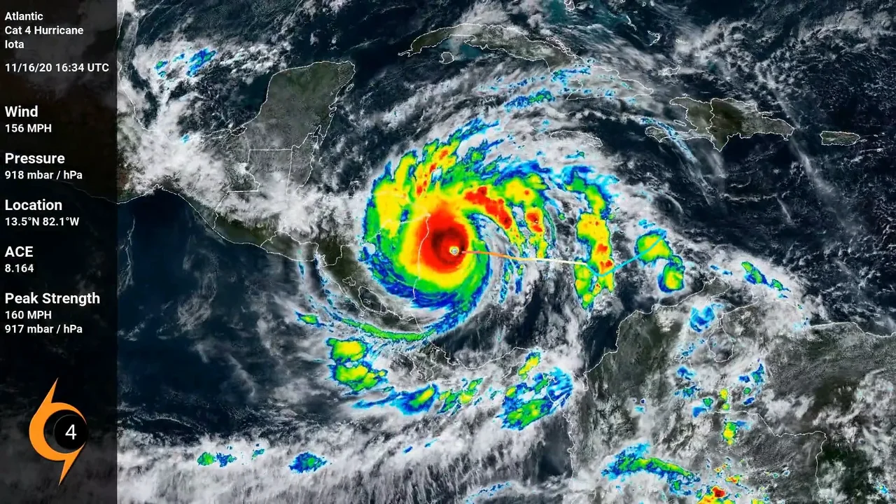
Iota began in the Caribbean when a low pressure system formed and quickly organized. Iota rapidly strengthened to the first category 5 storm of the season. Iota was also the latest forming cat 5 storm and makes it the first time there has been two major hurricanes in November. Major Hurricane Iota made landfall less than 15 miles south from where Major Hurricane Eta had made landfall just two weeks earlier.
Iota crossed Central America and entered the Pacific Ocean with barely any strength left. There was nearly a 0% chance it would redevelop in that basin.
Hurricane Isaias was the ninth storm of the 2020 Atlantic Hurricane season, and the earliest one on record. At this time, Isaias is responsible for 13 fatalities and an unknown amount of damages. Areas affected include West Africa, the Lesser Antilles, the Greater Antilles, the Bahamas, the entire East Coast of the United States, and Eastern Canada.
Peak: 85 MPH, 987 mbar /hPa.
Tropical Storm Beta was the twenty-second tropical system and twenty-third named storm of the hyperactive 2020 Atlantic hurricane season. The reason the storm was the 22nd overall but 23rd named is because Beta formed as Tropical Depression Twenty-Two between the systems that would become Vicky and Wilfred, but did not reach tropical storm status and thus receive a name until Wilfred and Alpha became named storms. Beta is the earliest forming twenty-third storm in recorded history, beating out 2005's Tropical Storm Alpha by 34 days.
Tropical Storm Beta was a slow moving meandering storms that spent a lot of time just floating around in the Gulf. Even before tropical development, the storms and low pressure swirl that eventually became Beta had been moving about the Gulf for days.
Slow moving, Beta dropped rain for days over the Gulf Coast regions.
Peak: 60 MPH, 994 mbar / hPa.
Major Hurricane Teddy was the twentieth tropical system and nineteenth named storm of the hyperactive 2020 Atlantic hurricane season. Teddy is the earliest forming nineteenth storm in recorded history, beating out 2005's unnamed Subtropical Storm by 20 days.
Major Hurricane Epsilon was the twenty-seventh tropical system and the twenty-sixth named storm of the hyperactive 2020 Atlantic hurricane season. Epsilon was the earliest forming twenty-sixth storm on record beating Tropical Storm Delta of 2005 by 34 days. Epsilon was also the fourth major hurricane of the 2020 season.
Epsilon is notable for having rapid intensification in the presence of a decent amount of shear at the mid-levels and over cool ocean temperatures. Most rapid intensification storms in October occur in the areas near the Caribbean.
Once Epsilon hit the north Atlantic, the storm's strength waned a bit while expanding the area of strongest winds. As of the making and uploading of this video, the remnants of Epsilon have combined with another non-tropical cyclone and are impacting the Irish and British isles.
Tropical Storm Kyle was the 12th tropical system and 11th named storm system of the 2020 Atlantic hurricane season. Kyle began as a storm system over eastern North Carolina where officials began keeping an eye on it. Once over the Gulf Stream, the storm gained Tropical characteristics and became a Tropical Storm.
The system struggled against shear from the get-go. While the circulation was closed, most of its center was exposed through vast parts of the storm's life. As quickly as it popped up, it disintegrated.
Peak: 50 MPH, 1000 mbar / hPa.
Tropical Storm Josephine was the 11th tropical system and 10th named storm of the so-far 2020 Atlantic season. Josephine became the earliest 10th storm beating 2005's Jose by 9 days.
Josephine struggled with wind shear and dry air over most of it's existence.
Peak: 45 MPH, 1004 mbar / hPa.
Major Hurricane Laura was the thirteenth tropical system and twelfth named storm of the 2020 Atlantic hurricane season. Laura was the earliest forming twelfth storm in recorded history. When the storm became a tropical depression, it did so around the same time as another tropical depression formed (later Hurricane Marco). At one point, both storms were predicted to make simultaneous landfalls on the US Gulf states as category 1 hurricanes. Laura remained under hurricane strength until reaching the Gulf of Mexico. Upon entering those water, rapid intensification quickly created a category 4 monster of a storm.
Laura made landfall near Cameron, Louisiana, just 1 mbar / hPa above its peak lowest pressure and tied the 1856 Last Island Hurricane as the strongest (deepest low pressure) to hit the US state of Louisiana.
As of August 31st, Major Hurricane Laura is estimated to have caused US$8 billion in damages.
Peak: 150 MPH, 937 mbar / hPa.
Tropical Storm Omar was the fifteenth tropical system and fifteenth named storm of the hyperactive 2020 Atlantic Hurricane Season. The storm that would become Omar became a tropical depression first, being given the numerical identifier 15L. However, the depression didn't strengthen to tropical storm status until after 16L. Thus, 15L received the later 'O' name and 16L received the 'N' name.
Omar affected no land directly while tropical, but did make landfall as an extratropical system over Scotland.
Peak: 40 MPH, 1003 mbar / hPa